
Tension mounts in Namutumba over 500-metre border dispute
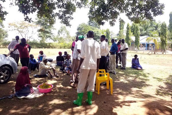

A section of Itonko residents gather under an avocado tree at Namutumba Town Council headquarters after delivering their petition.
A row has erupted in Namutumba Town Council after more than 300 residents from Itonko Village petitioned local leaders over an altered border line, warning that the unresolved land conflict could escalate into violence.
The dispute centers on a boundary shift between Itonko Village in South Ward and neighboring Namutumba Zone B. According to a petition submitted to the LCIII chairperson, Mr Sudasi Mushega, on July 1, residents and former local council leaders claim that the historic border—originally demarcated by the Iganga–Tirinyi–Mbale Highway—has been shifted nearly 500 metres deep into Itonko Village.
The alteration has effectively reclassified several vital administrative and social institutions into Namutumba Zone B. Affected properties include the Namutumba Town Council headquarters, Namutumba Health Centre III, and Namutumba Modern Islamic Primary School, as well as private estates such as that of Dr Fred Kasiisa.
Disgruntled residents contend that the Iganga–Tirinyi–Mbale Highway served as the recognized administrative boundary between Itonko and Kangulumo villages long before Namutumba District was carved out of Iganga District in 2006. In their petition, community members questioned the unilateral decision by Namutumba Zone B leadership to expand its territory without consulting Itonko authorities. They have also demanded clarity regarding compensation for landowners in Nakidudura Zone whose properties face ownership uncertainties under the revised map.
Supporting the petitioners, Mr Kabi Nabongho, the LCII chairperson for South Ward, expressed concern over the lack of transparency surrounding the shift and questioned why the town council's updated map reflects a 500-metre encroachment.
“The new boundary between Itonko and Namutumba Zone B was created to undermine the development of Itonko Village, rather than to improve service delivery and administration,” Mr Nabongho stated. He noted that the ongoing dispute has severely compromised local security and called on authorities to intervene before the situation deteriorates further. “We have brought this matter to your office. You either restore the old boundary to maintain peace in the area or leave it as it is and risk bloodshed.”
However, Ms Grace Mugabe, the LCI chairperson for Namutumba Zone B, defended the current territorial lines, explaining that the restructuring occurred naturally alongside the district's creation.
“It is true, as Itonko residents allege, that the old boundary was the Iganga–Tirinyi–Mbale Highway. But when Namutumba became a district and the town council was created from Namutumba Sub-county, new villages were created, resulting in changes to their boundaries,” Ms Mugabe said. She clarified that under the official Namutumba Town Council map, the disputed institutional administrative blocks and public facilities fall legitimately within Namutumba Zone B.
In response to the growing hostility, the Namutumba Town Council chairperson, Mr Sudasi Mushega, appealed to both communities for calm, emphasizing that local authorities are adhering strictly to executive cartography guidelines.
“I did not create the old or new boundary. Our guide is the town council map drawn by the Ministry of Local Government,” Mr Mushega explained, reassuring residents that the council will work within official Ministry channels and consider community welfare to resolve the stand-off peacefully.


 Museveni steps into Mulago land dispute
Ultimate Uganda
Museveni steps into Mulago land dispute
Ultimate Uganda
 HIV Alarm in Kampala: 211 New Infections Weekly Linked to Massage Parlours, Spas & Lodges
Ultimate Uganda
HIV Alarm in Kampala: 211 New Infections Weekly Linked to Massage Parlours, Spas & Lodges
Ultimate Uganda
 Uganda: ‘Delayed land acquisition stalling road works’
Ultimate Uganda
Uganda: ‘Delayed land acquisition stalling road works’
Ultimate Uganda
 Fearless Former Minister Criticizes M7 For Always Betraying Sr Colleagues While Claiming to Be Fighting Corruption, Urges Barugahara & Nameere to Watch their Back
Ultimate Uganda
Fearless Former Minister Criticizes M7 For Always Betraying Sr Colleagues While Claiming to Be Fighting Corruption, Urges Barugahara & Nameere to Watch their Back
Ultimate Uganda
0 Comments